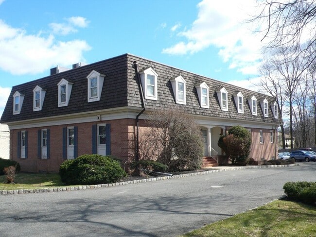
Property Record
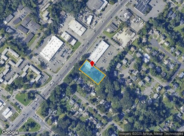
1100 Njsh 22E, Plainfield, NJ 07060
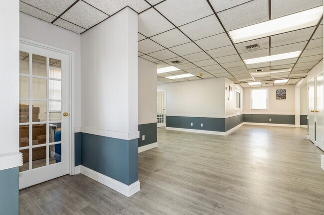

Current Lease Availabilities
NEARBY LISTINGS FOR SALE OR LEASE
Property Detail
1100 Njsh 22E
Lakewood-New Brunswick, NJ
West End Heights Park
14-00161-01-00002
ADDITIONAL LOTS: MAY 15
Officebuilding
Somerset
X
New Jersey
34023C0027F
2
2024
0.66 AC
2025
Route 22 East
039302
Northern New Jersey
DEMOGRAPHICS near 1100 Njsh 22E
1 Mile
3 Mile
5 Mile
2024 Total Population
13,900
116,666
236,385
2029 Population
13,744
114,997
234,589
Pop Growth 2024-2029
(1.12%)
(1.43%)
(0.76%)
Average Age
38
39
40
2024 Total Households
4,649
37,062
78,119
HH Growth 2024-2029
(1.03%)
(1.44%)
(0.77%)
Median Household Inc
$82,507
$84,592
$110,218
Avg Household Size
2.90
3.00
2.90
2024 Avg HH Vehicles
2.00
2.00
2.00
Median Home Value
$332,726
$382,545
$453,215
Median Year Built
1957
1955
1961
Nearby Places
Map Layers
Map Styles
 Street
 Aerial
- Restaurants
- Banks
- Shops
- Fitness
- Groceries
PUBLIC TRANSPORTATION
COMMUTER RAIL
Plainfield (Raritan Valley Line - NJ Transit Commuter Rail (NJ Transit))
DRIVE
WALK
Distance
Plainfield (Raritan Valley Line - NJ Transit Commuter Rail (NJ Transit))
5 min
2.0 mi
Dunellen (Raritan Valley Line - NJ Transit Commuter Rail (NJ Transit))
DRIVE
WALK
Distance
Dunellen (Raritan Valley Line - NJ Transit Commuter Rail (NJ Transit))
8 min
2.9 mi
AIRPORT
Newark Liberty International
DRIVE
WALK
Distance
Newark Liberty International
29 min
21.1 mi
Trenton Mercer
DRIVE
WALK
Distance
Trenton Mercer
65 min
39.7 mi
LaGuardia
DRIVE
WALK
Distance
LaGuardia
63 min
40.4 mi
Freight Ports
Maher Terminal
DRIVE
WALK
Distance
Maher Terminal
33 min
19.8 mi
Nearby Properties
Address
Land Use
TOTAL SIZE
Lot Size
Zoning
Address
Land Use
TOTAL SIZE
Lot Size
Zoning
20.08 AC
RML1
Address
Land Use
TOTAL SIZE
Lot Size
Zoning
26.87 AC
H-D
Address
Land Use
TOTAL SIZE
Lot Size
Zoning
10.09 AC
Address
Land Use
TOTAL SIZE
Lot Size
Zoning
27.70 AC
Address
Land Use
TOTAL SIZE
Lot Size
Zoning
34.27 AC
R65
Address
Land Use
TOTAL SIZE
Lot Size
Zoning
67.22 AC
R65
Address
Land Use
TOTAL SIZE
Lot Size
Zoning
233,217 SF
36.91 AC
LI5
Address
Land Use
TOTAL SIZE
Lot Size
Zoning
Address
Land Use
TOTAL SIZE
Lot Size
Zoning
15.79 AC
H-D
Address
Land Use
TOTAL SIZE
Lot Size
Zoning
12.47 AC
H-D
Address
Land Use
TOTAL SIZE
Lot Size
Zoning
19.84 AC
Address
Land Use
TOTAL SIZE
Lot Size
Zoning
16.97 AC
Address
Land Use
TOTAL SIZE
Lot Size
Zoning
30.80 AC
R10
Address
Land Use
TOTAL SIZE
Lot Size
Zoning
2,800 SF
16.73 AC
R20V
Address
Land Use
TOTAL SIZE
Lot Size
Zoning
4.74 AC
NC
Address
Land Use
TOTAL SIZE
Lot Size
Zoning
13.83 AC
CB
Address
Land Use
TOTAL SIZE
Lot Size
Zoning
19.84 AC
H-D
Address
Land Use
TOTAL SIZE
Lot Size
Zoning
30.40 AC
PR
Address
Land Use
TOTAL SIZE
Lot Size
Zoning
19.19 AC
R-3
Address
Land Use
TOTAL SIZE
Lot Size
Zoning
10,328 SF
7.53 AC
R4
Address
Land Use
TOTAL SIZE
Lot Size
Zoning
21.53 AC
H-D
Address
Land Use
TOTAL SIZE
Lot Size
Zoning
122,820 SF
14.65 AC
H-D
Address
Land Use
TOTAL SIZE
Lot Size
Zoning
12.52 AC
H-D
Address
Land Use
TOTAL SIZE
Lot Size
Zoning
23.45 AC
RHC
Address
Land Use
TOTAL SIZE
Lot Size
Zoning
11.20 AC
Address
Land Use
TOTAL SIZE
Lot Size
Zoning
0.39 AC
R5
Address
Land Use
TOTAL SIZE
Lot Size
Zoning
11.02 AC
Address
Land Use
TOTAL SIZE
Lot Size
Zoning
12.06 AC
Address
Land Use
TOTAL SIZE
Lot Size
Zoning
Address
Land Use
TOTAL SIZE
Lot Size
Zoning
The World's #1 Commercial Real Estate Marketplace
Connect with us
© 2026 CoStar Group
The information above has been obtained from sources believed reliable. While we do not doubt its accuracy we have not verified it and make no guarantee, warranty or representation about it. It is your responsibility to independently confirm its accuracy and completeness. Any projections, opinions, assumptions, or estimates used are for example only and do not represent the current or future performance of the property. The value of this transaction to you depends on tax and other factors which should be evaluated by your tax, financial, and legal advisors. You and your advisors should conduct a careful, independent investigation of the property to determine to your satisfaction the suitability of the property for your needs.